Researchers Employ LiDAR to Assess Streetscapes
Posted: May 11, 2021
 Researchers at the University of Colorado Denver are studying the use of a sophisticated surveying and remote sensing technology to assess and improve streetscapes.
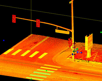
The researchers investigated methods to extract streetscape features with three different classes of light detection and ranging (LiDAR) processed with 3D volumetric pixels (voxels). LiDAR is becoming widely available for public use, and with its high precision and accuracy, the research suggests that the methods may provide the most objective 3D spatial location of streetscape feature data, which can ultimately be applied to better predict the impact of the streetscape environment on traffic safety, walkability, and other outcomes. LiDAR analytics have the potential to supplement and/or replace time-consuming and possibly subjective audit-based streetscape measures currently used.
Wesley Marshall, Ph.D.
University of Colorado Denver
A LiDAR-Based Approach to Quantitatively Assessing Streetscapes
MPC-21-430