


|
© 2024 Upper Great Plains Transportation Institute is a research and education center at North Dakota State University.
|
SMARTSe |
| Title: | Performance Analysis Via Vehicle Electronic Telemetry (PAVVET) |
| Principal Investigators: | Raj Bridgelall |
The International Roughness Index (IRI) and Power Spectral Density (PSD) are the two most widely utilized indices to summarize ride-quality and pavement condition. Producing them requires calibrated roughness profiling equipment and personnel with specialized training. Even with the latest high-speed profiling technologies, transportation agencies cannot afford the time and expense necessary to produce these indices more frequently than once per year. Consequently, symptoms of distress conditions go unnoticed, for example, frost heaves that appear in between data collection cycles and disappear afterwards. To mitigate these risks, agencies are seeking lower-cost approaches to comply with federal condition reporting requirements for the national highway network.
The IRI is strictly a ride-quality index, derived from the accumulated suspension movement of a simulated quarter-car, rolling over the elevation profile at a fixed reference speed of about 50 miles per hour. Characterizing roughness for urban roads is nearly impossible because IRI is undefined at other speeds. As a mechanical filter, the model emphasizes wavelength energy that excites the modal resonances, and attenuates those that fall outside of the filter pass-band. To compensate for wavelength biases that could mask some distress symptoms, practitioners often utilize the PSD. However, computing the PSD requires sample sequences from relatively long pavement sections, thereby limiting its use for localizing distress symptoms.
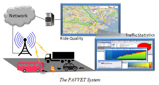
This project uses participatory sensing principles to produce an improved index of roughness characterization that combines the benefits of the IRI and the PSD. The road impact factor (RIF) is a multi-resolution, statistical model of roughness produced from sensors on connected vehicles traveling at any speed. Distributed sensors include smart phone apps that collect and process real-time location and inertial data with energy efficient algorithms that have negligible impact on battery life. A centralized cloud-based system combines the RIF into a time-wavelength-intensity-transform (TWIT), which is a wavelength-unbiased characterization of roughness from a broad range of vehicle types and speeds. A key research objective is to characterize the relationship between IRI and RIF, and to compare their performance. Another objective is to evaluate the performance of TWIT when used in pavement deterioration forecasting models.